Anak Krakatau Evolutionary History Reveals Why Asymmetric Growth Predetermined Its 2018 Structural Collapse

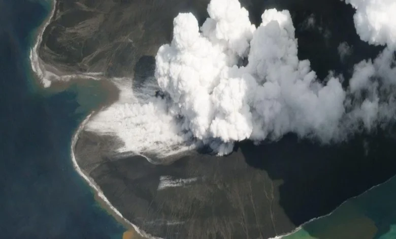
The iconic Anak Krakatau, the volcanic child born from the remnants of the catastrophic 1883 eruption of Krakatoa, has never possessed a symmetrical form. For nearly a century, scientists have observed its growth, yet it is only recently that the underlying geological reasons for its lopsided development have been fully decoded. New research presented by Professor Sebastian Watt of the University of Birmingham during the webinar titled "Volcanic Characteristics of the Krakatau Volcano: Magmatic Systems, Evolutionary History, and Real-time Tsunami Monitoring" reveals that the volcano’s structural instability in 2018 was not a random occurrence, but the culmination of a century-long developmental trajectory dictated by the seafloor upon which it rests.
The Geological Foundation of Asymmetry
The fundamental shape of Anak Krakatau was determined at the very moment of its emergence in 1927. The volcano sits on the rim of a submerged caldera, a massive crater left behind by the cataclysmic 1883 eruption. This location created a highly uneven foundation. To the northeast, the seafloor is relatively shallow, allowing volcanic material—tephra and lava flows—to accumulate rapidly and solidify in a stable environment. In contrast, the southwest flank of the island rests on significantly deeper water.
In these deeper areas, the volcanic material struggles to build up, leading to slower growth and a less stable foundation. "From its earliest days, the volcano exhibited asymmetry due to the topography of the seafloor," Professor Watt explained. This inherent imbalance dictated the path of least resistance for subsequent lava flows. Once the volcanic vent rose above sea level, this uneven base influenced how lava distributed itself, creating a structural bias that left the southwest flank dangerously overloaded and prone to failure. This long-standing geological predisposition was the primary driver behind the massive flank collapse on December 22, 2018, which triggered a deadly tsunami in the Sunda Strait.
A Century of Volcanic Chronology
To reconstruct the life of Anak Krakatau, researchers have synthesized nearly 100 years of data. The methodology is exhaustive, incorporating historical nautical charts, black-and-white photographs from the mid-20th century, contemporary satellite imagery, and high-resolution drone mapping.
The timeline of Anak Krakatau is one of persistent, rhythmic activity. Since its birth, the volcano has undergone phases of near-constant eruption, punctuated by decadal pauses.
- 1927–1950s: The island emerged and grew in a distinctly asymmetric fashion, with growth favoring the shallower northeastern side.
- 1960s: A shift occurred as material began to accumulate more heavily on the southwest side. By this period, the island’s profile briefly trended toward a more symmetrical shape.
- 1960–2018: Data indicates a period where the rate of growth by volume stabilized, suggesting that a significant portion of magma was being stored within the crustal reservoir rather than reaching the surface.
- 2018: The structural failure of the southwest flank resulted in a massive loss of volume, fundamentally altering the island’s morphology.
- 2018–Present: A period of intense post-collapse regrowth has been recorded, characterized by high-frequency eruptions that are currently being monitored for signs of deceleration.
Data-Driven Insights into Magmatic Behavior
The study of Anak Krakatau is arguably one of the most comprehensive long-term volcanic monitoring projects in the world. By integrating petrological data—the chemical composition and texture of volcanic rocks—with historical growth rates, scientists can now distinguish between periods of surface-level explosive activity and deep-seated magmatic loading.
Professor Watt notes that the slowing growth rate observed between the 1960s and 2018 provides a critical indicator for volcanologists. "When the growth rate slows, it often suggests that magma is becoming trapped beneath the surface, building pressure within the volcanic edifice," he stated. This "magmatic storage" is a crucial factor in assessing the stability of a volcano. When the edifice becomes too heavy or the internal pressure too great, a flank collapse becomes a distinct possibility.
The 2018 event, which saw the volcano lose a significant portion of its height and mass, serves as a benchmark for future hazard modeling. Since the collapse, the rate of eruptive activity surged before beginning to taper off. However, researchers caution that the current post-2018 phase is still in its infancy. Continuous monitoring is required to determine whether the volcano will return to its historical pattern of slow, steady growth or if it remains in a state of heightened volatility.
Implications for Global Volcanology
The research conducted by the University of Birmingham team is significant not only for the Sunda Strait region but for global volcanology. Most volcanoes are studied in snapshots; having a complete, detailed evolutionary record of a single vent for almost a century is rare. This "uncommon dataset" allows scientists to move beyond mere observation and into the realm of predictive modeling.
While the team is careful to emphasize that historical data cannot provide an exact calendar date for the next eruption or structural failure, it provides a "contextual blueprint." By understanding how the volcano behaved in the 1950s or the 1990s, scientists can better interpret real-time data from seismic sensors, GPS deformation monitors, and gas emission analysis.
The integration of surface morphology with subsurface structural understanding represents a shift in how geologists monitor island volcanoes. It is no longer enough to measure the height of a crater; one must understand the load-bearing capacity of the submarine slopes and the rheology of the magma chamber feeding the vent.
Future Monitoring and Public Safety
The tragic events of 2018 underscored the lethal potential of volcanic flank collapses, which can occur without the standard warning signs of a massive magmatic explosion. The work of Professor Watt and his colleagues provides the scientific foundation necessary to improve early warning systems.
For the Indonesian government and relevant geological agencies, the lesson is clear: Anak Krakatau is a dynamic system that "remembers" its past. The structural weaknesses that existed in 1927 continue to influence the volcano’s behavior today. By applying the lessons learned from the last 100 years, experts can provide more accurate risk assessments for coastal communities in Banten and Lampung, which remain in the shadow of this restless volcano.
Ultimately, the study serves as a testament to the importance of historical documentation in science. The maps and photos gathered by earlier generations of scientists have proven to be as valuable as modern satellite imagery. As Anak Krakatau continues to reshape itself, this century of knowledge acts as a vital tool in interpreting the complex, often unpredictable language of the earth. Understanding the evolution of the past remains the most reliable guide for navigating the hazards of the future.